Visiting Grenen is more than ticking a box. Many travelers see the clashing waves but miss the deeper story. This guide reveals how the collision of two seas creates a living landscape, a haven for wildlife, and the unique ‘Blue Hour’ light that inspired an entire art movement. It’s your key to experiencing the elemental soul of Denmark’s northernmost point, not just observing it.
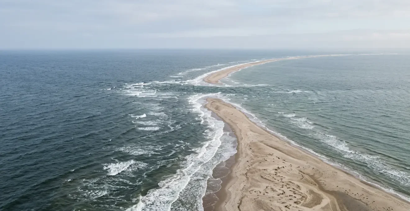
Imagine standing on a sliver of sand at the very top of Denmark, a place so elemental it feels like the edge of the world. This is Grenen. To your left, the turbulent waves of the Skagerrak sea; to your right, the calmer waters of the Kattegat. For bucket-list travelers, the iconic photo with one foot in each sea is the ultimate prize. It’s a tangible, physical connection to a unique geographical marvel.
Most guides will tell you how to get that photo. They’ll point you to the car park and mention the tractor-bus. But what if the real magic isn’t just the line in the water, but the powerful, unseen forces that draw it? The raw energy of this place has sculpted more than just sand. It has shaped a unique ecosystem, buried churches, and created a quality of light so extraordinary that it gave birth to an entire art movement. This is the story of Grenen that is often missed.
This guide will take you beyond the photo op. We’ll explore the science behind the clashing waves, the best ways to traverse the country to reach this northern outpost, and the secrets hidden within its shifting dunes. You will discover why this coastline is a photographer’s dream, a birdwatcher’s paradise, and a painter’s muse. Prepare to truly understand the elemental power of Grenen.
To help you navigate this incredible destination, we’ve structured this guide to answer all your key questions. From the natural phenomena to the practical logistics, here is your complete roadmap to an unforgettable experience at Denmark’s northern tip.
Summary: Your Journey to Denmark’s Elemental Northern Tip
- Kattegat vs Skagerrak: Why Do the Waves Clash but Not Mix?
- Train or Car: What Is the Best Way to Cross the Country to Skagen?
- Den Tilsandede Kirke: How Did Sand Dunes Swallow a Church?
- Is It Safe to Swim Where the Two Seas Meet?
- Bike Rental in Skagen: Which Paths Lead to the Best Secluded Beaches?
- Where to Find the Most Photogenic Coastlines in Denmark?
- Vejlerne: Why Is the Limfjord Area a Mecca for Birdwatchers?
- Why Did Painters Flock to Skagen for the ‘Blue Hour’?
Kattegat vs Skagerrak: Why Do the Waves Clash but Not Mix?
The spectacle at Grenen is a direct result of fundamental physics. The two seas, the Skagerrak (part of the North Sea) and the Kattegat (part of the Baltic Sea), have different densities, salinities, and temperatures. This prevents them from readily mixing, creating the distinct, visible line where their waves meet and crash against each other. It’s a powerful, constant collision of two massive bodies of water, a battle of currents that is both audible and visual. You are not just seeing a line in the water; you are witnessing a profound natural boundary.
This constant turmoil is also what makes Grenen a living landscape. The sediment carried by the currents is continuously deposited at the tip. In fact, scientific studies show the sand spit grows by approximately 10 meters per year, constantly reshaping Denmark’s northernmost point. The land you stand on is newer than the land a few steps behind you.
This collision zone is more than just a geological curiosity; it’s a vibrant, nutrient-rich ecosystem. The turbulent water churns up food, creating a prime feeding ground that attracts an incredible diversity of marine life. As detailed in an analysis of Grenen’s wildlife, gannets are often seen diving along the separation line, and the area is a year-round home to porpoises and seals. With a bit of luck, you might even spot dolphins, whales, or orcas, making it Denmark’s premier location for observing sea mammals.
Train or Car: What Is the Best Way to Cross the Country to Skagen?
Reaching Skagen, the gateway to Grenen, is an adventure in itself, offering a glimpse into the changing Danish landscape as you travel north. The two primary options from major cities like Copenhagen or Aarhus are by train or by car, each offering a distinct experience. A train journey allows you to relax and enjoy the scenic views without the stress of driving, while a car provides the ultimate flexibility to explore the charming coastal towns and natural sights of North Jutland at your own pace.
To make the best choice, consider the trade-offs between travel time, cost, and flexibility. This comparative data gives a clear overview of what to expect:
| Transport Mode | Duration (Copenhagen) | Cost Range | Key Advantages | Key Disadvantages |
|---|---|---|---|---|
| Train (DSB) | 6-8 hours (via Aarhus/Frederikshavn) | Variable (DSB Orange tickets from 99 DKK) | Scenic views, no driving stress, environmentally friendly | Long journey, requires transfers |
| Car | 5 hours (320 miles/515 km) | $100-$160 (fuel + tolls) | Flexibility to explore coastal routes, stop at Råbjerg Mile or Lønstrup | Parking fees at Grenen, driver fatigue |
| Long-distance Bus | 8.5 hours (via Aalborg/Frederikshavn) | $30-$80 | Most economical option | Longest travel time, less comfortable |
Once in Skagen, you still have the “last mile” to cover to reach the very tip of Grenen. You have several excellent local options:
- The Sandormen Tractor-Bus: This iconic, oversized tractor-bus is a classic Skagen experience. It departs frequently from the Grenen parking area and takes you right to the water’s edge.
- Bicycle: For the most authentic local experience, rent a bike in town. A scenic 6-7 km ride along designated paths through the dunes is the perfect way to absorb the landscape.
- Walking: A paved trail makes the 30-45 minute walk from the parking area accessible for everyone, including those with strollers or wheelchairs.
- Local Bus: Public buses run from Skagen town center to the Grenen parking area, offering a convenient and affordable option.
Den Tilsandede Kirke: How Did Sand Dunes Swallow a Church?
Long before Grenen became a tourist destination, it was a place of immense and destructive power. The most dramatic evidence of this is Den Tilsandede Kirke, or The Sand-Buried Church. All that remains visible today is the proud, whitewashed tower of what was once the main parish church for Skagen, dedicated to Saint Lawrence of Rome. The rest of the 14th-century structure lies buried beneath meters of sand, a silent monument to the relentless force of nature in this region.
The culprit behind this incredible event is a phenomenon known locally as “sandflugt”—sand-drift. For centuries, the fine, coastal sand, carried by the powerful westerly winds, migrated inland, swallowing everything in its path: farms, fields, and finally, the church itself. Parishioners had to dig their way into the church for services until 1795, when the battle was lost and the church was abandoned by royal decree.
This image captures the micro-level reality of the same process that buried a cathedral-sized building. The winds relentlessly push individual grains of sand, which accumulate over time to form massive, shifting dunes. The church tower stands today not just as a picturesque landmark, but as a stark reminder of the elemental power that defines North Jutland—a power you can still feel in the wind and see in the ever-changing dunes on your way to Grenen.
Is It Safe to Swim Where the Two Seas Meet?
The short and absolute answer is no. While the allure of swimming at the confluence of two seas is strong, it is strictly prohibited by law, and for a very good reason. The powerful collision of the Skagerrak and Kattegat creates extremely strong, unpredictable, and life-threatening rip currents. These currents can pull even the most experienced swimmers out into the open sea in an instant. This is not a gentle meeting of waters; it is a turbulent and dangerous zone.
Historically, these waters were notoriously hazardous. Before the first lighthouse was built in the 18th century, the shallow, shifting sandbars of Grenen were known as a “ship graveyard,” responsible for countless wrecks. The same powerful underwater forces that once grounded ships make swimming an unacceptable risk today. Signs are posted clearly along the beach, and it is imperative that all visitors heed these warnings.
However, you can still have the quintessential Grenen experience. Wading a few feet into the shallows on either side of the tip is permitted and is precisely what most visitors do for the iconic photo. Even when wading, especially with children, exercise extreme caution. The pull of the water can be surprisingly strong even at ankle depth. For actual swimming, Skagen offers wonderful, safe alternatives. The beaches on the eastern Kattegat side, such as Sønderstrand and Damstederne, are sheltered and known for their much gentler waters, making them perfect for a relaxing swim.
Bike Rental in Skagen: Which Paths Lead to the Best Secluded Beaches?
To truly experience Skagen like a local, there is no better way than by bicycle. The flat landscape, extensive network of dedicated paths, and breathtaking scenery make it a cyclist’s paradise. Renting a bike from one of the many shops near the train station gives you the freedom to explore beyond the main tourist trail, discovering secluded beaches, hidden viewpoints, and the very landscapes that inspired the Skagen Painters. The journey becomes as memorable as the destination.
Here are three signature bike routes that offer a perfect introduction to the area’s diverse beauty:
- The Art & Light Route (12-15 km): This cultural loop takes you from the town center to Skagens Museum and Anchers Hus, where you can see the masterpieces, before heading to Sønderstrand beach and the historic Vippefyret lighthouse for panoramic views.
- The Grenen Nature Route (13-14 km): The most direct path to the main attraction. Follow the designated trail through protected dunes, past WWII bunkers, and towards Det Grå Fyr (The Grey Lighthouse), which you can climb for spectacular views before reaching the tip of Grenen.
- The West Coast Sunset Route (16+ km): For an unforgettable evening, ride out to Gammel Skagen (Højen) to witness the famous ‘blue hour’. This is the quintessential experience of the Skagen light, best enjoyed from the west-facing coast.
Insider Tip: Accessing Secluded Spots via Skagen Klitplantage
For those looking to escape the crowds, the Skagen Klitplantage (dune plantation) offers a network of hidden trails. As documented by travelers who have explored these paths, a fantastic option is the 11.6-kilometer loop that starts at the Vippefyret, follows the beach to Grenen, and then returns through a peaceful nature reserve. This route is rarely crowded and offers an authentic sense of solitude and connection with the unique landscape, revealing views of the sea and hills that most visitors miss.
Where to Find the Most Photogenic Coastlines in Denmark?
While Grenen’s dramatic meeting of seas is arguably one of Denmark’s most iconic photo opportunities, the country’s 7,300-kilometer coastline is a treasure trove of diverse and stunningly photogenic landscapes. The beauty of the Danish coast lies in its variety, from the wild, windswept dunes of the west to the calm, fjord-like inlets of the east. In North Jutland, the photogenic appeal is defined by the raw, untamed nature of the landscape. The vast, sandy beaches, rolling dunes covered in lyme grass, and the ever-present historical remnants like WWII bunkers create a powerful, moody atmosphere for photographers.
The key to capturing great photos here is to focus on the light and texture. The low, often soft Nordic light creates long shadows and highlights the fine details of the sand and waves. The stark, minimalist beauty of a solitary bunker against a dramatic sky or the sweeping curve of the coastline disappearing into the sea mist are classic North Jutland compositions. The area around Gammel Skagen and the paths leading to Grenen offer endless opportunities for this kind of elemental photography.
But Denmark’s coastal beauty isn’t limited to sand. Further south, the country offers entirely different, yet equally breathtaking, scenes. The dramatic white chalk cliffs of Møns Klint, plunging into the turquoise Baltic Sea, present a stark and beautiful contrast to the sandy landscapes of Skagen.
This geological drama showcases a different facet of Denmark’s natural charm. Whether it’s the raw power of Grenen or the majestic serenity of chalk cliffs, the Danish coastlines offer a rich palette for any photographer willing to explore their shores. It’s a landscape that is as dynamic and full of life as the birds that use it as a superhighway.
Vejlerne: Why Is the Limfjord Area a Mecca for Birdwatchers?
While Vejlerne and the Limfjord are renowned birdwatching areas in their own right, the absolute epicenter of Danish ornithology is right here at Grenen. The area’s unique geography makes it a critical migratory “funnel” on the East Atlantic Flyway, a superhighway for birds traveling between their Siberian breeding grounds and wintering areas in Africa. This concentration of migratory traffic means Grenen holds the record for the highest number of observed bird species in all of Denmark, making it an undisputed mecca for birdwatchers.
The experience is overwhelming for the senses. It’s not just visual; it’s an auditory cacophony of calls, honks, and the powerful beat of thousands of wings. The spring migration, in particular, is a world-class spectacle.
Grenen is Northern Europe’s best spring migration spot for birds of prey.
– Sandormen Official, Sandormen Grenen Tourism Information
During April and May, with favorable southeast winds, the skies can fill with massive flocks of birds, including majestic sea eagles, golden eagles, and ospreys, all gathering strength before making the crossing to Sweden. For anyone with an interest in nature, witnessing this event is an unforgettable experience. Even for a first-timer, getting started is easier than you think.
Your First-Timer’s Birdwatching Plan at Grenen
- Choose Your Time: Aim for dawn or dusk during the spring migration (April-May) for maximum activity, especially for birds of prey.
- Gather Essential Gear: Even inexpensive binoculars will transform your experience. A camera with a telephoto lens is highly recommended for capturing the action.
- Find Your Spot: Position yourself anywhere along the Grenen peninsula. The entire area acts as a natural funnel, concentrating the birds.
- Know What to Expect: Prepare for an overwhelming sensory experience. Look for large flocks of common birds, and keep an eye out for the rarer, larger raptors soaring above.
- Watch the Wind: Check the weather forecast. The number of birds increases dramatically with southeast winds, which push them towards the coast.
Key Takeaways
- Grenen is a dynamic, growing landform, not a static point, expanding by approximately 10 meters each year.
- The collision of the Skagerrak and Kattegat seas creates a unique ecosystem for wildlife and the famous “Blue Hour” light.
- Experiencing the area by bicycle is the most authentic way to discover its hidden paths and painterly landscapes.
Why Did Painters Flock to Skagen for the ‘Blue Hour’?
The story of Skagen is incomplete without the story of its light. In the late 19th and early 20th centuries, this remote fishing village became the center of the Scandinavian art world, attracting a vibrant colony of artists now famously known as the Skagen Painters. Figures like P.S. Krøyer, Anna and Michael Ancher, and Holger Drachmann were drawn here not just by the rustic charm, but by a quality of light they could find nowhere else on Earth.
This unique luminosity is a direct consequence of Skagen’s geography. With the sea on both its east and west coasts, the landscape is bathed in a remarkable “double-lit” effect. The phenomenon is most pronounced during “den blå time,” or the blue hour—the magical period of twilight about 20-30 minutes after sunset. During this time, the deep blue of the twilight sky is reflected by the sea on both sides, enveloping the entire landscape in an ethereal, intensely vibrant blue glow.
The Skagen Painters’ Trail: From Canvas to Coastline
The painters dedicated themselves to capturing this fleeting, magical light. Today, you can walk in their footsteps and experience this connection between art and nature firsthand. A visit to the Skagens Museum reveals masterpieces like Krøyer’s “Summer Evening on Skagen’s Southern Beach,” showcasing the famous blue light. Afterward, you can visit the actual locations depicted in the paintings, such as Sønderstrand beach or the historic Brøndums Hotel. Seeing the art and then standing in the very spot where it was created provides a profound understanding of why these artists flocked to this remote tip of Denmark to chase the light.
Understanding the “blue hour” is understanding the soul of Skagen. It is the final piece of the puzzle, where the raw elemental forces of geography—the sand, the wind, and the two seas—combine to create something of sublime, artistic beauty. It perfectly encapsulates the magic of this unique place.
Now that you understand the soul of Grenen, from its clashing seas to its painterly light, the next step is to plan your own journey. Go and stand where the waves of Kattegat and Skagerrak tell their endless story, and experience the elemental magic of Denmark’s northernmost point for yourself.
Frequently Asked Questions about Visiting Grenen
Why is swimming prohibited at Grenen?
The collision of the Skagerrak and Kattegat creates extremely strong and unpredictable rip currents that can pull even experienced swimmers out to sea. Swimming is prohibited by law due to the life-threatening danger posed by these powerful currents.
Can I wade in the water at Grenen?
Yes, wading a few feet into the shallow water on each side is permitted and is what most visitors do for the iconic ‘foot in each sea’ photo. However, extreme caution is required even when wading, especially with children, as the currents can be strong.
Where are safe swimming beaches near Skagen?
Safe swimming alternatives include sheltered beaches on the calmer Kattegat (east) side, such as Sønderstrand and Damstederne, which are known for gentler waters. The west side beaches are also generally safe for swimming, though always check local conditions.
What is the historical significance of Grenen’s dangerous waters?
Before the White Lighthouse was built in 1747, Grenen was notorious as a ‘ship graveyard’ where countless vessels ran aground on the shallow reef. The same powerful currents that created this maritime hazard continue to make swimming dangerous today.